Table Mountain is one of South Africa's most recognisable landmarks. Rising over 1,000 metres above Cape Town, it is also one of Africa's premier tourist destinations.

It is now Thursday afternoon and I am still hobbling around like an old man. This is not really due to the fun run and cycle over the weekend, but more so because this past Monday, a public holiday (Family Day) here in South Africa, I climbed Table Mountain.

My friend Jamie and I organised the expedition up the mountain, and myself and my Dad acted as the tour guides. Montassir, my brother-in-law, and Eric, an islander from Tristan Da Cunha in the South Atlantic Ocean, also joined us, along with five other American girls - all friends of Jamie. And of course I mustn't forget to mention my dog Scruffy - who at eleven years of age came along as well.

We set out from Cecilia Forest on the south side (and the back) of Table Mountain in the early morning and hiked up to the Contour Path from where we trekked across to Skeleton Gorge - our route up to the Back Table of the mountain. This gorge is located above Kirstenbosch National Botanical Gardens and is filled with huge boulders that make for some dramatic scenery, and in winter a waterfall cascades down this ravine.

After two or so hours of climbing up we came out on the Back Table, where there are dams that in the past used to supply the City of Cape Town with water. Some of them are empty now (coming off a long summer) - but will fill up again during the winter months. We then headed uphill for another couple of hours. (Although to keep spirits up - and probably more because I didn't exactly know how far it was to the top - I kept telling everybody "only another 30 minutes." This became the phrase of the day.)

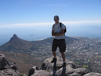
Eventually, after around four and a half hours of hiking, we emerged at the highest point of Table Mountain, MacLear's Beacon, at an altitude of 1,085 metres above sea-level. (That's around 3,560 feet for American readers.) At this point it was just me and the six Americans as my Dad, Montassir, and Eric had dropped back to take it easy. It made me think of my many adventures on Mercy Ships when it was just me and a group of (usually) American girls.
After a few minutes rest at the top we walked across the top of the mountain (which is mostly flat - hence the name "Table Mountain") to the Cableway where we enjoyed the views down on Camps Bay and the centre of town. We also grabbed some lunch at the restaurant there.

Despite sore legs and the temptation of the Cableway, we all decided to hike down Platteklip Gorge, which overlooks the City side of the mountain. This route zig-zags all the way down the narrow ravine and is pretty tiring on the legs! After two hours of constant downhill, at soon after 17h00-ish, we finally came out at Tafelberg Road, the highest road above the City.

Here the girls caught their taxi home and we were met by my Mom who drove us all home. It was a pretty tiring day - but oh so worth it! Not only in terms of the breathtaking views and beautiful plants, but also the quality of the people who hiked in our group. It was a great day and much fun was had by all. Feel free to click on the images to see them bigger.
 It is now Thursday afternoon and I am still hobbling around like an old man. This is not really due to the fun run and cycle over the weekend, but more so because this past Monday, a public holiday (Family Day) here in South Africa, I climbed Table Mountain.
 My friend Jamie and I organised the expedition up the mountain, and myself and my Dad acted as the tour guides. Montassir, my brother-in-law, and Eric, an islander from Tristan Da Cunha in the South Atlantic Ocean, also joined us, along with five other American girls - all friends of Jamie. And of course I mustn't forget to mention my dog Scruffy - who at eleven years of age came along as well.
  We set out from Cecilia Forest on the south side (and the back) of Table Mountain in the early morning and hiked up to the Contour Path from where we trekked across to Skeleton Gorge - our route up to the Back Table of the mountain. This gorge is located above Kirstenbosch National Botanical Gardens and is filled with huge boulders that make for some dramatic scenery, and in winter a waterfall cascades down this ravine.
 After two or so hours of climbing up we came out on the Back Table, where there are dams that in the past used to supply the City of Cape Town with water. Some of them are empty now (coming off a long summer) - but will fill up again during the winter months. We then headed uphill for another couple of hours. (Although to keep spirits up - and probably more because I didn't exactly know how far it was to the top - I kept telling everybody "only another 30 minutes." This became the phrase of the day.)
 Eventually, after around four and a half hours of hiking, we emerged at the highest point of Table Mountain, MacLear's Beacon, at an altitude of 1,085 metres above sea-level. (That's around 3,560 feet for American readers.) At this point it was just me and the six Americans as my Dad, Montassir, and Eric had dropped back to take it easy. It made me think of my many adventures on Mercy Ships when it was just me and a group of (usually) American girls.
 After a few minutes rest at the top we walked across the top of the mountain (which is mostly flat - hence the name "Table Mountain") to the Cableway where we enjoyed the views down on Camps Bay and the centre of town. We also grabbed some lunch at the restaurant there.
 Despite sore legs and the temptation of the Cableway, we all decided to hike down Platteklip Gorge, which overlooks the City side of the mountain. This route zig-zags all the way down the narrow ravine and is pretty tiring on the legs! After two hours of constant downhill, at soon after 17h00-ish, we finally came out at Tafelberg Road, the highest road above the City.
 Here the girls caught their taxi home and we were met by my Mom who drove us all home. It was a pretty tiring day - but oh so worth it! Not only in terms of the breathtaking views and beautiful plants, but also the quality of the people who hiked in our group. It was a great day and much fun was had by all. Feel free to click on the images to see them bigger.
1 comment:
Great blog and love all the details and pictures! It was a super fun day!
Post a Comment